
Beach driving is a much-loved part of life on our coast. People use four-wheel drives to fish, launch boats, reach quiet stretches of beach and spend time with family. Vehicles on beaches and in dunes can also put pressure on safety, dune systems, wildlife and other beach users.
The PNP and its nine member local governments are preparing a regional strategy for four-wheel drive (4WD) and off-road vehicle (ORV) use on the coast from Rockingham to Busselton. A 4WD is a road-registered four-wheel drive vehicle. An ORV is a vehicle that is not registered for road use, such as a quad bike, trail bike or dune buggy.
This is about balance, not a ban. The aim is to maintain recreational beach driving while protecting the environmental, social and cultural values of the coast.
Why a regional strategy?
Our coast does not stop at council boundaries, and neither do the people who use it. Many beach users drive between neighbouring beaches, and rules, signs and management currently differ from one local government to the next. A regional approach means:
- consistent rules, signs and information that are easier to understand and follow
- neighbouring councils and State agencies working together instead of separately
- changes at one beach are planned with the next beach in mind
- lessons from what already works locally are shared along the coast.
What will the project do?
- Identify where and how vehicles are used on the coast, including formal and informal access tracks.
- Understand what people value about the coast and what concerns them.
- Review current management, rules and resourcing.
- Develop practical, prioritised actions for the region and for each local government.
The project will deliver a regional 4WD and ORV Management Strategy, a local action plan for each local government, and recommendations for implementation and future funding. It builds on work already done, including local coastal hazard plans and foreshore management plans, and will not replace them.
Where does the project cover?
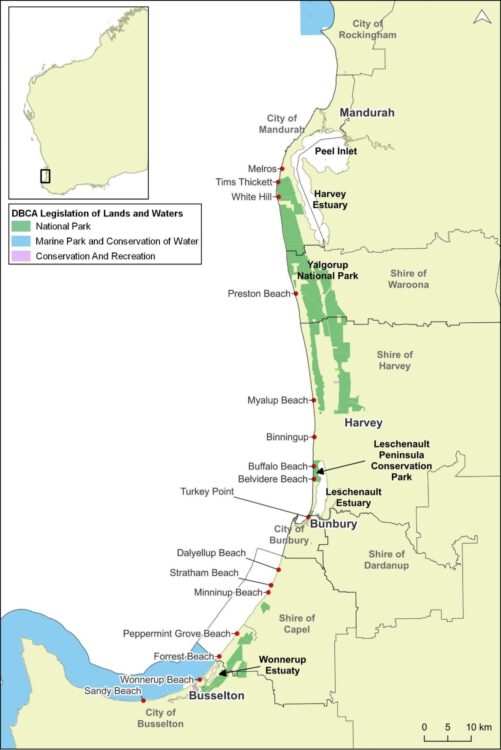
The coast within the Cities of Rockingham, Mandurah, Bunbury and Busselton and the Shires of Murray, Waroona, Harvey, Dardanup and Capel.
Who is involved?
The PNP is leading the project on behalf of its member local governments, and Seashore Engineering has been engaged to deliver it. A steering group of local government and State Government representatives guides the project. A stakeholder reference group of community, user and environmental groups will provide local knowledge. Community input will shape the strategy through a survey, drop-in sessions and comment on the draft plan.
Where is the project up to?
The project runs from September 2026 to late 2027 in four stages. We are currently in Stage 1.
- Setting the context (September to December 2026): site visits and discussions with each local government and its Rangers, and a review of existing plans, rules and legislation.
- Assessment and evaluation (early 2027): access points and tracks mapped, community survey and drop-in sessions.
- Draft strategy (mid to late 2027): draft regional strategy and local action plans released for public comment.
- Final strategy (late 2027 onwards): strategy finalised and considered by each council.
The steering group has met and the project team has visited beaches in Waroona, Busselton and Bunbury with local government staff and Rangers, including a community meeting at Preston Beach. Visits to other local governments are planned through late October and early November. Latest update, October 2026.
How can I have my say?
Everyone who uses, lives beside or cares for the coast can have a say, including people who do not drive on the beach.
Community survey: coming soon. An online survey will open in early 2027 and run for several weeks. The link will appear here, and paper copies will be available locally.
Drop-in sessions will be held along the coast in early 2027. Dates and venues will be published on this page and through your local council.
Community associations, coastcare and environmental groups, 4WD clubs and other user groups in each local government area will be invited to nominate one representative to the stakeholder reference group.
To hear when the survey and drop-in sessions open, please email the project team.
Where can I find out more?
Answers to common questions about the project, beach access, permits and how input will be used are in the Frequently asked questions document. A one-page summary of the project and how to get involved is in the Project flyer, which can be printed or shared.
What we hear will be summarised and published on this page after each stage. Individual responses will not be identified.
Something to report now?
This project is not a reporting service. To report unsafe or damaging behaviour on a beach, contact your local council’s Rangers. In an emergency call 000.
The PNP would like to acknowledge the Western Australian Government, which partly funded this project through the CoastWA program.